Mount Mitchell Trail

At A Glance


5.6 mi one-way
Difficulty Rating: 5.6 ![]()
Steepness: Climbs Steeply ![]()
Tread Condition: Very Rough ![]()
Trail Number: 190
Hikes That Use This Trail: Mount Mitchell
Description
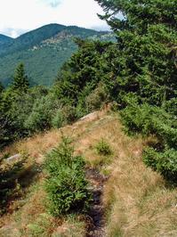
This long, strenuous trail leads from the USFS Black Mountain Campground to the summit of its namesake mountain. Most of the trail is on USFS property. Climbs 3600 ft in 5.5 mi, making it one of the highest single-trail climbs in the region. It's steep and rough in sections, but there are spectacular views. You'll travel through a mixed hardwood forest at lower elevations and dense, old-growth spruce forests in upper elevations and almost pure stands of Fraser Fir at the top. An alternate trail to Higgins Bald adds 0.2 miles to the length. This path is shared with the Mountains to Sea Trail along its entire route.
Intersecting Trails
This trail is located in the Mount Mitchell State Park area. For a list of all the trails in that area, see the Mount Mitchell State Park trails list page.
This trail also crosses into these trailhead areas:
All Photos from the Trail


GPS Map
Map Information
Download GPS Data
Click on a route, trail, or point on the map and select the GPS Data tab to download its data.
Data Formats
KML (Google Earth)
KML is the main file type used by Google Earth. If you have Google Earth installed, clicking the KML link should open the trail or point directly in Google Earth for viewing. This is the native file format used by Google Earth, but many other map applications can use and understand KML as well, so if you're not sure which one to download, KML is a good bet.
GPX
The GPX format stands for GPS Exchange - a free, open, XML format for exchanging GPS and map data. GPX is compatible with Google Earth, many other mapping programs, and most GPS devices (such as Garmin). Load the file directly into your GPS to help find your way on your next trip!
GeoJSON
GeoJSON is a newer, lightweight data exchange format which can be used to quickly share map data and may have a smaller size than KML or GPX. Many professional mapping and GIS applications support the GeoJSON format.
About the Map
Copyright
Base Layers
Base layers provided by OpenStreetMap, the US Geological Survey, the US Forest Service, and NC OneMap. Base layer images are subject to the respective copyright policies of their owners. Base layers may not be available at all times due to system maintenance or outages.
WNCOutdoors Base Layer
The WNCOutdoors Base layer is provided by WNCOutdoors.info. It is licensed by Creative Commons Attribution 3.0.
Trail and Marker Overlays
Trail layers and downloadable data are all original works created by WNCOutdoors with guidance from a variety of sources, including ensembles of our own GPS tracks, user contributed GPS tracks, official maps and GIS data from government agencies, and field observations. WNCOutdoors data is made freely available under the Open Database License - you are free to copy and use it for any purpose under the terms of that license (summary).
Tips
- Hover over a trail to see it highlighted. Helps to see start and end points for an individual trail.
- Scroll and zoom the map before printing, and that view will persist into the printed image.
- Click a trail for more details and to download it individually.
Trail Segments
Trails are often made up of several connecting paths which may have different characteristics, allowed uses, and seasons. This trail is divided into multiple segments as follows:
Black Mountain Campground to Higgins Bald E. Junction
- Allowed Uses: Hiking
- Length: 1.39 mi
Higgins Bald E. Junction to Higgins Bald W. Junction
- Allowed Uses: Hiking
- Length: 0.92 mi
Higgins Bald W. Junction to Buncombe Horse Range Trail
- Allowed Uses: Hiking
- Length: 1.1 mi
Junction with Railroad Grade to Commissary Campsite
- Allowed Uses: Hiking
- Length: 320 ft
Commissary Campsite to Balsam Nature Trail
- Allowed Uses: Hiking
- Length: 1.2 mi
Balsam Nature Trail to Summit Path
- Allowed Uses: Hiking
- Length: 0.25 mi
Summit Path to Observation Tower
- Allowed Uses: Hiking
- Length: 505 ft
Mountains to Sea - Mount Mitchell - Between Briar Bottom
- Allowed Uses: Hiking
- Length: 71 ft
Briar Bottom - Split to Mt. Mitchell Tr.
- Allowed Uses: Hiking
- Length: 0.16 mi
Briar Bottom Rd - Entrance to Trail Split
- Allowed Uses: Hiking
- Length: 375 ft
BM Campground Rd - Bridge Access
- Allowed Uses: Hiking
- Length: 265 ft
Total Calculated Length: 5.32 mi
This value is derived from our underlying map data, and it may not match officially published information.
Feedback
Ratings
Average Rating: 3.6 (rated 11 times)
Rate It Now:

Rick P said: A friend and I hiked this trail on Jan 2, 2019. There was no cost to enter the park or hit the trail. My friend is an avid indoor rock climber, and I had been treadmill training and had done several shorter 2hr moderate-to-difficult hikes (Crowder's Mountain) over the couple of months leading up to this hike. So we were both in pretty good shape for our age (both 50+). It was VERY challenging. It took us 3 1/2 hrs up and 2 1/2 hours down. We were pushing ourselves and hiking at a pretty fast pace up, so I can't imagine getting up any faster. We could have made it down faster were it not for my friend's bad knee. We didn't do any trail running, so required time is all about your hiking pace. We had a clear day and the views at the summit were spectacular, but not many unobstructed views on the way, even with the leaves off the trees. So this was more of a fitness hike than a scenic hike for us (until we got to the summit where we spent 20mins enjoying the views). Beware of the roughness of the trail. Many rocks and roots. We hit snow covered trail about 3/4 of the way to the top and had ice, snow and slush to deal with from that point up. The trail was pretty wet in several spots due to the combination of previous days' rain and melting snow. I would definitely do this hike again as a fitness training hike and wish I lived closer to be able to do it more regularly.
Jon A said: 4 hours up and 3 hours to hike down for two in-shape adults. This trail is strenuous. Wear hiking boots and avoid sneakers. I went after the rain and had to cross several wet sections.
Amy said: My husband and I (both in our early 30s), hiked the Mt. Mitchell on 6/18/15, starting at the Black Mtn. campground. Beautiful weather, but a little warm and humid (low 80s) especially at the beginning before we gained some elevation. We hiked from the bottom to the very top (observation deck at the top of the mountain)....took us 2 hours and 11 minutes to do the climb, with that being said we stopped maybe twice to take quick breathers, snack and take a couple photos, but besides that we were hauling butt and power hiking. Spent about 20 minutes at the top to use the restroom, take photos, and grab a quick snack at the snack bar. Then it took us 1 hour and 35 minutes to hike back down to the campground. On the way down we ran about 3/4 of the way, on the downhills and some of the flat spots. We found it was easier to run down some parts rather than walking because we were more likely to trip if we were walking quickly (we were wearing trail running sneakers, no hiking poles). Trail was dry with the exception of some slippery rocks around creek areas, up until the last 30 minutes of our hike down when it started raining. Overall was a fun and challenging trail! My husband stubbed his toe on a root on the way down, and I slightly overturned my ankle, but besides that we were okay. We were more going for how quickly we could make it up and down, didn't stop much to take in the scenery. But I'd do this trail again.
Sean said: Completed the up and down in just under 7 hours. We started at the black mt campground. the total climb to the parking lot and the peak is closer to 7 miles, the mt' mitchel trail is listed at 5.6 but its another 1.5 to the observation deck. this climb is no joke, it's steep then get's steeper. Lot's of rocks and roots, have a good pair of hiking boots to save the ankles. A trekking pole is a must have to help the knees on the way back. Having completed the up and back I would NEVER do this hike again. It was brutal and there are no views, this is strictly a hike to test yourself and cross it off the list. The weather was beautiful on 5/10/15 but we still exhausted our water before the top and we refilled at the concession stand and emptied the hydration packs before reaching the bottom. A change of clothes is a must unless you want to drive home in soaking wet gear. the blue ridge is a beautiful place and should be seen.
judy Caldamone said: Hiked this mountain 2 years ago with my two Marine Grandsons, I was 67 also and trained for 5 months.. It was a strenuous climb and rained the entire way but we trudged through and reached the summit in 4 1/2 hours, so disappointed there was no visibility when we reached the summit, no tourists either.. we took a break at the store for a bit, then started our downward climb, which took us 4 hours, so glad I was able to do this with my Grandsons, such a great experience for all of us! plan to climb Mt. Washington in July to celebrate my 70th Birthday with my Son! So glad I'm able to do this!!
Mike said: How would the trail be in late October ? Is the camp at Toe River still open to camp in. Is there a way to catch a ride back down to the camp on the river if you only want to hike "up" the trail? Thanks, 67 and still hiking, Mike
rcamero1 said: Hiked this August 1, 2013. 65 degrees and sunny at the Black Mt Campground (nice place, tent camped right next to Toe River, clean facilities, hot showers, etc., .3 mi from trailhead, so it's really 6 miles each way), but 55 degrees in total overcast drizzle at the top. Toughest trail my wife and I have done (and we've done lots in NC, some in Grand Canyon). Saw numerous unprepared hikers (sandals, no water, no additional clothes to shorts/tshirts), wish them the best, but they'll be miserable & maybe at risk. Trail is overgrown at various points such that you get soaked trudging through if the plants are still wet with dew or rain and such that footing is tricky if it's wet (which it was for us the whole way down, thanks to showers). Few views even in the clear since it's almost all under tree canopy, and don't expect to see Mt Mitchell at all. Trail is rated "most strenuous," and they mean it, so water, hiking sticks, snack, extra clothes are beyond comfort and into safety considerations. Lousy GPS and no cell phone coverage most of the route, with a couple of chances to take a wrong turn, so take a good map. We set a steady, not relaxed but no sprint, pace, and it took almost 4 hours each way (rainshowers on way down slowed what would have been faster, since it's mostly stones and roots and mud that get slick on the descent). We drove to the top and "pre-hiked" from Mt Mitchell to Mt Craig on our first day, did the whole Mt. Mitchell Trail route from the campsite on the 2nd day. The Mt Craig was a mile or so out, then back, and gives a good indication of how the trail conditions will be, the terrain you'll be on, etc., if you've got doubts. All that said, I'm in my late 60s & in decent but not athlete shape, so don't be deterred, just be prepared! If you're looking for views, it's not worth the considerable effort. If you're looking for a challenge of a most strenuous rated long hike, and the reward for having done the Eastern U.S.'s highest peak at the end, go for it - we're glad we did, now that we're recuperated! Oh, and at the top, the nice kids at the concession stand serve up a hot chocolate that was mighty fine for us tired & wet climbers!
travis said: yes they are open in may. and there is no fee to hike but if you stay at the campground at the top theres a small fee. there are places to camp on some trails in the backcountry and does not cost anything if your backpacking. and you do need some hiking boots dont wear sneakers. and bring a jacket the weather can change fast there and it gets pretty cold ant night best thing to do is get a map to hope this helps.
Richa Parikh said: Hello, A group of us will be coming down on May 1st. I had a few questions: Is the trail open on May 1st? Are there any fees? Do we need any hiking equipment or are comfortable clothing and running shoes fine? Is there a place to camp near the top? Please let me know soon. Thanks, Richa Parikh