Shut-In Trail
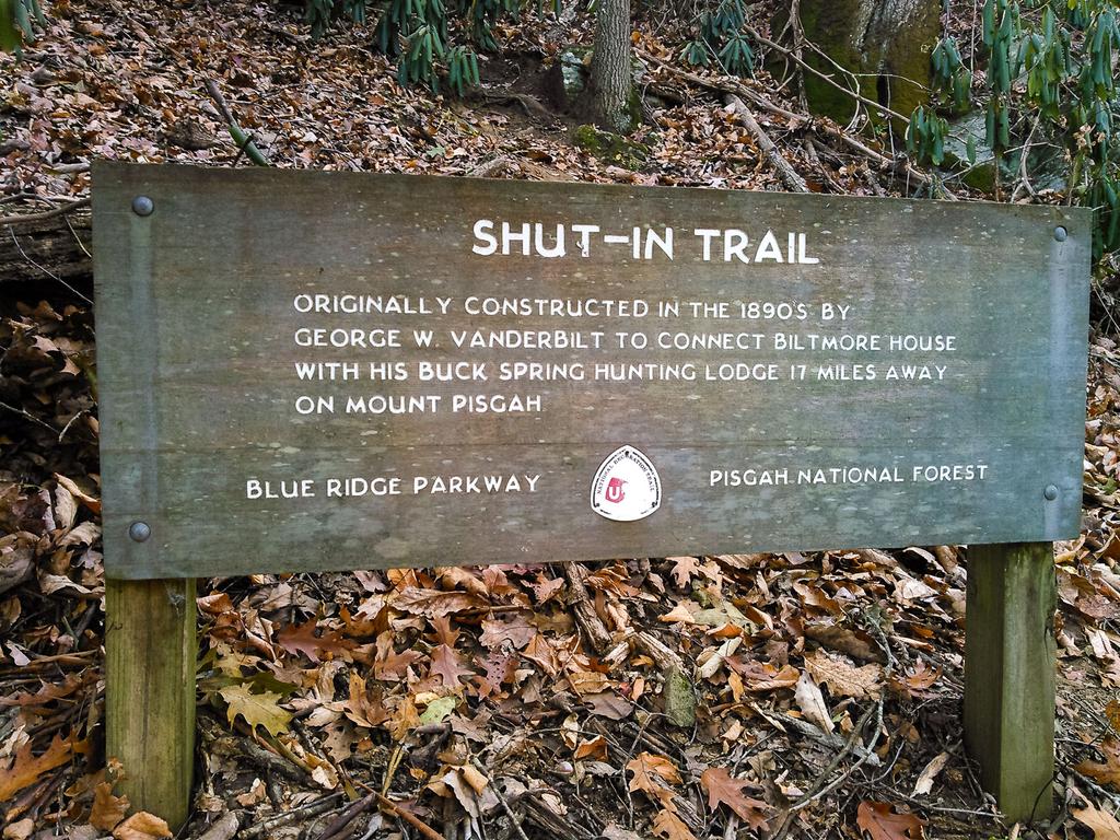
The Shut-In Trail is a long, historic route which travels from NC 191 near Bent Creek and Asheville to the Mount Pisgah parking area. George W. Vanderbilt, builder of the famous Biltmore Estate near Asheville, constructed the Shut-In Trail around the year 1890. He used it to climb the Pisgah Ridge, linking his hunting lodge at Buck Springs below the summit of Mt. Pisgah to his famous Estate.


Although parts were obliterated with the construction of the Blue Ridge Parkway, much of this trail still follows its original route. The trail was named by Vanderbilt for the ridge which it ascends, which was in turn named nearly a century earlier for the fact that it "shut in" the Bent Creek valley from the adjacent French Broad River valley.
Though the trail can be used as a long-distance route, it is most frequently used for short exercise and day hikes. This is generally necessary since overnight camping is not allowed along the Parkway (and 16.3 miles, with 3000 feet of vertical climbing, is a bit long for most day hikers). Those wishing to hike the trail with an overnight stop must plan a side trip onto adjacent Pisgah National Forest land to make this work.
Not everyone limits themselves to day hikes, though. For over 20 years the Shut-in Ridge Run has been using the trail as an event venue, on the first Saturday in November. Joggers cover the entire 18 miles on this run. You can get more information on the official website.

The trail follows the same path used by the Mountains to Sea Trail for its entire length.
There are many convenient access points where the trail touches and crosses the Blue Ridge Parkway, mainly at overlooks. Commonly used access points include:
- The beginning of the trail on the ramp to NC 191 (BRP MP 393.7, very limited parking) or park at the French Broad River overlook and walk back (BRP MP 393.8)
- A brush with the trail in Bent Creek at BRP MP 395.1 (parking here is road-side and somewhat limited)
- Walnut Cove Overlook, BRP MP 396.4
- Sleepy Gap parking area, BRP MP 397.3
- Chestnut Cove overlook, BRP MP 398.3
- Bent Creek Gap, BRP MP 400.3
- Beaver Dam Gap Overlook, BRP MP 401.7
- Stony Bald Overlook, BRP MP 402.6
- Big Ridge Overlook, BRP MP 403.6
- Mills River Valley Overlook, BRP MP 404.5
- Elk Pasture Gap/NC 151 Junction at BRP MP 405.5
- The end of the trail at the Mount Pisgah Parking Area, BRP MP 407.6
Since you're close to the Parkway (never more than about 1/2 mile) and not far from Asheville, expect lots of hiker and jogger traffic on the trail.
Map
Here is a map of the Shut-In Trail, showing the location of the access points in the list above.
Map Information
Download GPS Data
Click on a route, trail, or point on the map and select the GPS Data tab to download its data.
Data Formats
KML (Google Earth)
KML is the main file type used by Google Earth. If you have Google Earth installed, clicking the KML link should open the trail or point directly in Google Earth for viewing. This is the native file format used by Google Earth, but many other map applications can use and understand KML as well, so if you're not sure which one to download, KML is a good bet.
GPX
The GPX format stands for GPS Exchange - a free, open, XML format for exchanging GPS and map data. GPX is compatible with Google Earth, many other mapping programs, and most GPS devices (such as Garmin). Load the file directly into your GPS to help find your way on your next trip!
GeoJSON
GeoJSON is a newer, lightweight data exchange format which can be used to quickly share map data and may have a smaller size than KML or GPX. Many professional mapping and GIS applications support the GeoJSON format.
About the Map
Copyright
Base Layers
Base layers provided by OpenStreetMap, the US Geological Survey, the US Forest Service, and NC OneMap. Base layer images are subject to the respective copyright policies of their owners. Base layers may not be available at all times due to system maintenance or outages.
WNCOutdoors Base Layer
The WNCOutdoors Base layer is provided by WNCOutdoors.info. It is licensed by Creative Commons Attribution 3.0.
Trail and Marker Overlays
Trail layers and downloadable data are all original works created by WNCOutdoors with guidance from a variety of sources, including ensembles of our own GPS tracks, user contributed GPS tracks, official maps and GIS data from government agencies, and field observations. WNCOutdoors data is made freely available under the Open Database License - you are free to copy and use it for any purpose under the terms of that license (summary).
Tips
- Hover over a trail to see it highlighted. Helps to see start and end points for an individual trail.
- Scroll and zoom the map before printing, and that view will persist into the printed image.
- Click a trail for more details and to download it individually.


