Crabtree Falls Hike

This popular, short loop descends on a moderate path to a majestic 70 ft waterfall, which is widely touted as one of the most photogenic in the area. You'll climb steeply up the opposite ridge for a short distance, then hike a wide, smooth trail beside the stream. Many very large trees populate the forest in this area. Finish out the loop by climbing gently through a beautiful hardwood forest. The hike starts in a Blue Ridge Parkway campground, which makes a good base camp for further explorations into the area. You'll share this trail with many others during the summer, but if it's winter (and especially if the gate is closed), you'll likely have it all to yourself.
At A Glance
 3 mi round-trip
Difficulty Rating: 4.14 ![]()
Tread Condition: Some Obstacles ![]()
Climb: Hilly ![]()
Lowest Elevation: 3280 ft
Highest Elevation: 3760 ft
Climb Total: 480 ft
Configuration: Loop
Starting Point: Signed parking area at Crabtree Meadows Campground, milepost 339.5
Trails Used: Crabtree Falls Loop
Hike Start Location
Directions
From Asheville, follow the Blue Ridge Parkway north for 41 miles to the Crabtree Meadows area. Turn left and head into the former visitor center parking area. The signed trail starts at the northeast side of the parking area.
Formerly, you could park closer to the campground, but the small parking lot there was insufficient for the number of people who visit the falls and has been closed. So parking at the much larger visitor center is now required, along with hiking a short extension trail out to the old parking area and start of the trail. Fortunately, it's a nice addition to the trail which adds to the hike overall.
Details
Hike Description

Start the hike on the paved trail behind the parking area. It winds down the short paved section, goes past an old amphitheater for the campground, and through a meadow filled with wildflowers along an old woods road. In just under 0.2 mi there is a fork; bear right to stay on the path to the falls. (This is signed). You'll come out on the campground road after about 450 feet. Ahead of you and to the right (across the campground road) is the old parking area. And at the back of that parking area is the old trailhead and a trail sign.
This trail sign lists the hike as a 2 mile strenuous loop, but the map more accurately depicts the situation. It is 0.6 miles to the falls and 1.9 miles from the falls back to the campground, so it's actually a 2.5 mile hike from this spot. When you add in the 1/2 mile out-and-back from the visitor center, that brings the grand total for the hike to 3 miles. But the only truly "strenuous" section is a short one on either side of the falls, where the trail climbs steeply up and down the ridge. Aside from those, it levels out and gets relatively easy again. "Strenuous" is used in context with those who might typically use this Park Service campground, but for users of this web site comparing trails across Western NC, "moderate" is a more accurate description of the difficulty as a whole.
Take the trail behind the sign board. You will immediately walk beneath a thicket of Rosebay rhododendron. This becomes a beautiful tunnel of white flower petals in July, and in some seasons I've seem them last into early August. You'll quickly reach the intersection with the other side of the loop; you can go either way but for this hike let's get to the good stuff: turn right to begin the descent to the falls.

The trail is wide, smooth, and graveled at first, and takes you through a mixed hardwood forest, just at the lower fringe of the Northern Hardwood tree species zone. All along the loop, you will notice some very large trees. Excellent examples of oaks, maples, tuliptrees, and hemlocks show that this forest is maturing and should one day be considered old-growth due to its Federal protection from logging and development as part of the Blue Ridge Parkway.
The trail goes downhill through a shallow, high cove with a mostly dry stream bed at the bottom. As you reach a point where the stream becomes much steeper, it spits the trail out onto the mountainside to the right, which it begins to traverse. Here, the trail surface becomes considerably rougher. It's about here where you can start to hear the falls as well.
The trail switches back and forth several times before reaching the base of the falls. You will encounter some rocky sections, sets of rock steps, roots, and wet areas. There is plenty to look at and enjoy along the trail - you could make it last the whole day if you had to, and it would be well worth the walk!

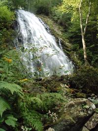
At the base of the 70 ft falls, the trail crosses a nice wooden bridge with a viewing bench built right in to it. A lone birch tree, present in nearly everyone's wide-angle shot of the falls, grows in the middle of the stream on an "island" below the cascading water. The falls is especially photogenic as the water spreads into a wide veil on the way down. Good vantage points for photography can be found from the left and right banks, and even from directly in front.
Take care when leaving the trail - boulders and rocks can be very slippery. On a hot day, there is a nice wading pool at the base - which requires a tricky climb over some boulders to get to - but the constant mist will keep you quite cool. There is absolutely no way to the top of the falls.
If you are continuing the loop, the hardest part of the hike is just past the falls. (If you are not, be prepared for a fairly steep climb back out - just not as bad as on the other side of the loop.) You'll climb 200 ft or so in the next 1/4 mile. The trail climbs steeply and switches back many times as it ascends the ridge. It seems to "bounce" from large tree to large tree, with one tree - here an oak, there a poplar - anchoring the tip of each switchback.
Nearing the top, the Park Service has provided a nice resting bench, which you might actually want to use - because the next section goes directly up a long set of stairs! You'll then achieve the nose of the ridge, follow it for just a little while, and then begin traversing the mountainside where some stone retaining walls have been built to hold up the trail. The steepness lessens a little here.

You'll then reach a rocky outcrop that seems to be part of the same geologic feature that forms the falls. This cool section of the trail sort of clings to the side of this rock cliff, but it's wide and safe, if you just stay on the path. A handrail is provided when the trail climbs some more steps around this nose of rock. At the top of the steps, and to to the left, is an opening in the trees with a decent view (especially in the winter).
Since most people will hear falling water and be curious: yes, there is also a very faint, mostly obscured view of the falls below. But to see it, you have to get too close to the edge and lean out. Trust me, this crappy view is not worth the risk. Stay on the main trail. A bench is provided here, and it is much more pleasant than being on the receiving end of a search and rescue mission.
This is the top of the really steep climb, and from here the trail widens and is mostly smooth. It actually descends slightly to reach the creek, and crosses a small tributary on a wooden bridge. There are some huge hemlocks growing in this area, and the other vegetation is typical of streamside areas in the mountains. Glimmering pools at the base of small rapids and cascades contain mountain trout - keep an eye out to see them darting in and out of the sunlit areas.
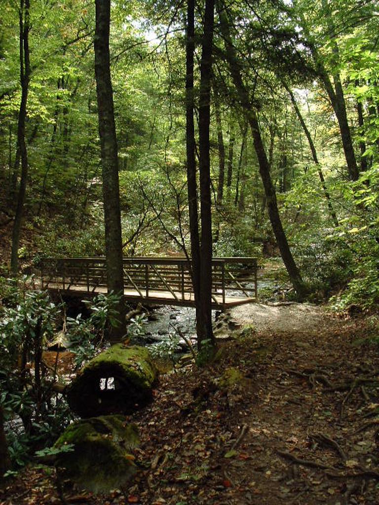
You'll cross the main stream on an impressive new bridge - a great improvement over the bouncy log that existed here before. The structural members of the bridge are fiberglass-infused polyester resin. This corrosion-resistant, lightweight, easy-to-assemble structure represents a new design being used in trail bridges. I hope it catches on, because the bridge is convenient to hikers, safe, and its light green color is unobtrusive in this forest setting. It should also be long-lasting; it was still in great shape at least 12 years after its installation.
Beyond the bridge, the trail first follows, and then gradually pulls away from, the creek. It will round a small, very low ridge, then descend just slightly again and begin following a small tributary upstream.
Some northern hardwoods grow in this area, as well as several large-leafed Fraser magnolias. These trees, also known as Mountain Magnolia, have the largest leaves of any native Southern Appalachian tree, and they can also be recognized by their growth habit: lots of saplings shooting up from the roots of the main trunk, or a cluster of large, main trunks on older trees. You'll also pass beneath maples and oaks, as well as birches and beeches.

You'll cross the small tributary on a log bridge. I've always found this section of the forest to be exceptionally quiet and relaxing. Except once, while crossing this bridge on a hike with my father, when we stopped on the bridge to take a drink and - by pure coincidence - listened as an enormous tree come crashing to the ground, somewhere in the distance. It was a clear, still fall day making the sound seem like it came out of nowhere - and a rather eerie experience!
Just past the crossing, you'll head a little more steeply uphill until you reach the highest seep of the tributary and enter drier woods. The the trail climbs moderately up to another signed intersection. Continuing straight takes you to the back loop of the campground, and it's just a short walk along the campground roads back to your vehicle from there - so you could knock off about .3 mile from the hike by going that way.
The loop trail officially goes left, which is the way measured for this hike. It travels through more mixed hardwood forests on a nicely graded path to the close of the loop.
Turn right at this last intersection to head back up to the old parking area. Continue straight across the campground road to the trail leading back to the visitor center, your vehicle, and to the completion of the hike.
All Photos from This Hike


Map
Green highlight indicates the route to follow within the trail network for this hike.
Tip: Printing this map? You can pan and zoom the map as desired before printing to show the area you need.
Map Information
Download GPS Data
Click on a route, trail, or point on the map and select the GPS Data tab to download its data.
Data Formats
KML (Google Earth)
KML is the main file type used by Google Earth. If you have Google Earth installed, clicking the KML link should open the trail or point directly in Google Earth for viewing. This is the native file format used by Google Earth, but many other map applications can use and understand KML as well, so if you're not sure which one to download, KML is a good bet.
GPX
The GPX format stands for GPS Exchange - a free, open, XML format for exchanging GPS and map data. GPX is compatible with Google Earth, many other mapping programs, and most GPS devices (such as Garmin). Load the file directly into your GPS to help find your way on your next trip!
GeoJSON
GeoJSON is a newer, lightweight data exchange format which can be used to quickly share map data and may have a smaller size than KML or GPX. Many professional mapping and GIS applications support the GeoJSON format.
About the Map
Copyright
Base Layers
Base layers provided by OpenStreetMap, the US Geological Survey, the US Forest Service, and NC OneMap. Base layer images are subject to the respective copyright policies of their owners. Base layers may not be available at all times due to system maintenance or outages.
WNCOutdoors Base Layer
The WNCOutdoors Base layer is provided by WNCOutdoors.info. It is licensed by Creative Commons Attribution 3.0.
Trail and Marker Overlays
Trail layers and downloadable data are all original works created by WNCOutdoors with guidance from a variety of sources, including ensembles of our own GPS tracks, user contributed GPS tracks, official maps and GIS data from government agencies, and field observations. WNCOutdoors data is made freely available under the Open Database License - you are free to copy and use it for any purpose under the terms of that license (summary).
Tips
- Hover over a trail to see it highlighted. Helps to see start and end points for an individual trail.
- Scroll and zoom the map before printing, and that view will persist into the printed image.
- Click a trail for more details and to download it individually.
Feedback
Ratings
Average Rating: 4.0 (rated 6 times)
Rate It Now:

Alexis Dixon said: I’m planning on going on this hike on September what is the weather like?
Christa Black said: If you click on the google maps directions for Crabtree Falls, you end up in Mills River, NC. No trails. So this should be corrected, or the google maps link deleted.
heather walker said: Coming to AVL this week (returning home!!) and bringing friends - want to show them a great waterfall hike (in the rain probably.) But...how far is this from Asheville? is it really a 2 hour drive? THANK YOU!
Rianne Clark said: Can you camp here?
Michael Henderson said: This is a must hike with one of the most beautiful waterfalls in the area. The hike is on the moderate side depending on which side you go, if you want a easier hike go counter clock wise, if you want more of a workout go clockwise. Love this one.
Don Vinuch said: Just got back from hiking the Crabtree Falls trail. Took about 2.5hrs for me (64yrs old) my wife (62) and a friend (60) if us old farts can do it anyone can. Beautiful falls and good moderate trail.
Nancy Sigmon said: I hiked it mid May, and was amazed at the number of wild flowers along the trail - trillium, bloodroot, solomans seal, Jack in the pulpit, mayapple, galax, dwarf iris, bluets, and something I'm pretty sure was lady slipper though it wasn't in bloom. There were many more wild flowers that I couldnt ID. It was incredible to see so many in such abundance. Oh and the waterfall was pretty cool too...
Jennifer said: Hello everyone! Are dogs allowed on any of these trails?
LK said: We did this hike yesterday, 8/22/14. The weather was certainly cooler than our home (Greenville, SC) - probably by 10 degrees but the humidity did catch up with us by the end of the hike. We took trail A to the Falls; fairly step, rooty and rocky but definitely doable - just pay attention to where you plant your feet - moderate hike - enjoyable. The Falls are beautiful and one can get rather close to the base to experience the cool spray and get some good photos. To do this - facing the Falls - we climbed the right side rock area to get to the 'pool' at the base. Just be careful - a bit wet but again, doable. The stairs that lead to trail B are repaired - no problem getting to the second apart of the loop. It is indeed steep as this trail rises to the bench mentioned in the (excellent) description above. The bench is a very welcome respite. The trail does eventually widen and has a gradual incline or is level. Very nice and appreciated(except for the humidity - bring water to drink). Most hikers returned from the Falls on trail A instead of completing the loop with trail B. Trail A is shorter. They looked bedraggled and quite worn out. Too steep for us - we opted to return on the longer, smoother trail offered on loop B. Sad to see the camp grounds abandoned and over-grown. Don't let that deter you from the Crabtree Falls Trail itself - a very nice hike - even for this not-so-in-shape 52 year old.
John Levins said: About how long does it take to do this hike? Planning a fall drive and would love to do this if, say, it's around a couple of hours or so. If some kind soul could email me at jl.temp2@gmail.com that would be stellar!!
[Site Admin] Jordan M. said: Cameron: the campground is closed, and backcountry camping is not allowed on National Park (Blue Ridge Parkway) property. You can camp anywhere in the nearby Pisgah National Forest or another area campground though!
Cameron said: Does any one know if you can camp out there?
Cassandra said: Re: Andrew Keast We did the trail yesterday with my 3 year old and 6 year old. Obviously the 3 year old had to be carried at times but the 6 year old did fine. Your kids should have no trouble, good hike!
andrew keast said: I want to take my two kids 8 & 6 yrs old on this hike. Does anyone feel it's too difficult for them? they are quite sporty and quite strong but dont want to deter them from future hikes if this is too tough. Pls help. Thanks.
Vistas said: Thank you so much for this review/synopsis of the Crabtree Falls hike. These kind of descriptions are very helpful in planning hikes and I know where I'll be this weekend! The pictures and captions are fantastic as well.
Lynn McKinney said: I just hiked this trail today and would like you to consider adding that the artificial stone steps that start the steep climb up the bluff immediately after you leave the bridge at the base of the falls have collapsed in part, due to soil erosion, and that 25 feet of the trail is currently a very hazardous climb. This part of the trail badly needs maintenance.
kim said: great hike in shenandoah
Eunice Jones LaMee said: This is a magnificent trail and bit of scenery. The above description adequately describes what you'll see (and endure.) Even though this hike is strenuous in sections, as long as you start the trip in good daylight, you'd have all day to accomplish this feat. At the bottom, the view is worth every huff and puff to get there and back. I've taken the hike twice, with the last one being last year (and I'm 62 YO.) A great day trip.