Grandfather's Profile Hike

Ascending Grandfather Mountain's Profile Trail, this hike takes you past some of the features that inspired its name. You'll ascend from the middle elevation creeks and streams, past a variety of features including views and rock outcroppings, and onto the summit ridge where a rare spruce-fir forest grows. Bring your camera, because a nearly endless supply of scenery awaits, and the trek is strenuous enough that you'll want to rest periodically anyway. Of all the trails in the region, this one has received more construction and maintenance attention than nearly all others over the years, leaving it in tip-top shape. The hike ends at the top of Calloway Peak, which at 5964 ft, is the highest mountain in the Blue Ridge range.
At A Glance
 7.6 mi round-trip
Difficulty Rating: 12.97 ![]()
Tread Condition: Moderately Rough ![]()
Climb: Climbs Steeply ![]()
Lowest Elevation: 3800 ft
Highest Elevation: 5964 ft
Climb Total: 2300 ft
Configuration: Out-and-back
Starting Point: Profile Trail Parking Area on U.S. Hwy. 105
Trails Used: Grandfather, Profile
Hike Start Location
Directions
From the intersection of US 221 and NC 105 in Linville, NC, go North on NC 105 for 4.3 miles. The entrance to Grandfather Mountain State Park's Profile Trail parking is on the right 0.3 mi past junction of Hwy. 184, beyond the ABC store.
From the intersection of US 221 and NC 105 in Boone, NC, it's 12.6 miles South on NC 105 to the State Park entrance, on the left.
Follow the entrance road about 1/4 mile to the large new parking area for the Profile Trail. The State Park building with restrooms, a covered patio area, water, and a boot washing station marks the start of the trail.
Details
Hike Description
Begin the hike at the back side of the restrooms building. This well-constructed new segment of trail (opened in 2017) traverses the slopes at an elevation of just around 4000 ft. A large, sturdy bridge spans a gulch near the beginning, and then the trail travels up and down some on timber steps.

It's a beautiful northern hardwood forest you're hiking through with a few Red Spruce and Eastern Hemlock mixed in. It's a beautiful start to the hike, but you'll enjoy the sights of nature more than any sounds since you're right beside the busy highway and it's rather noisy with trucks and other vehicles coming up the steep grade at high speed. (In fact, the only real complaint I'd have about this hike, besides the crowds, is that the faint sound of traffic - especially motorcycles - stays with you all the way to the summit).
A short series of switchbacks carries you down a descent to the fledgling Watauga River. This is where the new section of trail joins the original, and the old Tweetsie Railroad bed is across the river here. You'll see the old trail coming in from a creek crossing to the left, now closed. The trail continues following the Watauga downstream for a short distance, losing just over 200 ft. of elevation from the parking area. Remember, this means you'll have to finish the hike with a climb on the way back, so save some energy!

The trail undulates up and down some, with a few side curves into smaller adjoining coves where tiny streams or seeps flow in. There are some great photo opportunities here with wildflowers in spring, and it's a nice easy hike. The forest at this point is mostly mid-elevation and cove hardwood trees, with plenty of rhododendrons in the understory.
After less than 1/2 mile, the trail swings right and begins climbing. It's not too difficult at first, and the trail is well-graded and well-maintained. (Last time I hiked here, in 2021, a major bypass was under construction in this area. A ranger we met indicated that it should be open within a few months, bypassing a formerly steep, muddy, and eroded section).
You'll see the first handy milepost beside the trail. These are present all the way to the top of the mountain and indicate how far you've gone (or have left to go on the way back). There are some roots and rocks to contend with, but nothing major.
The trail winds its way up onto a low ridge with lots of beech trees, then heads back into a larger cove where you cross a stream. Some rather large trees grow here (as they do all the way up the trail to the spruce-fir zone).

The trail exits the cove and dips into the next one, where you cross scenic Shanty Branch on very large, parallel rectangular stepping stones. A small cascade is just upstream, and a larger one is just downstream. The trail swings left, downstream, to pass through the cleft between a big bluff to the right and a boulder that split off the bluff to the left, next to the cascading stream.
The trail climbs again past the bluff, and gets a bit steeper, but not terribly so. It wraps into progressively drier coves as far as running water goes, but lush carpets of greenery and wildflowers still grow on the rich soil of the forest floor. The rhododendron fades away, and is replaced by Hobblebush (Viburnum lantanoides) which has neat white flowers in mid-May. The trail then begins a series of switchbacks taking you to progressively higher elevations. A few more Red Spruce trees start to mix in with the hardwoods as you move through 4000 to 4500 feet in elevation.
Foscoe View makes a nice little rest stop at approximately the halfway point of the hike (distance-wise), with limited vistas to the north and west. You can see lots of development on the surrounding mountains, making it apparent why protection of land on Grandfather Mountain is so important, and the view stretches to the Amphibolite Mountains and even the mountains of Virginia near the horizon.

Beyond Foscoe View, the trail starts getting rockier, but most of the rocks are artfully arranged in a stair-step fashion. Another series of switchbacks will provide more (wintertime) views up to the looming Profile Cliffs on Green Ridge above you. You'll soon reach the Profile campsite on the left.
The section of trail just beyond the Profile campsite goes through a wetter area as it swings back to the southwest, but it is almost entirely paved with hundreds of huge, flat stones. Named "Peregrine's Flight", this part of the trail is as outstanding to the world of trailbuilding as the infamous Linn Cove Viaduct of the Blue Ridge Parkway on the opposite side of Grandfather Mountain is to roadbuilding.
The trail was built by Kinny Baughman and Jim Morton using nothing more than hand tools - iron rods, shovels, pulleys, and winches. According to rangers I've spoken with on the mountain and an article in the Mountain Times, it was built between 1985 and 1989 in order to replace the soon-to-be-obliterated Shanty Trail and preserve hiking access to the west side of Grandfather Mountain. Baughman is quoted as referring to the Profile Trail as his "lasting legacy", and with that I'd agree - the course of this walkway, defined in stone, looks like it could easily be here for centuries, and it is a true pleasure to hike!
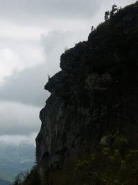
After passing a few more switchbacks and rock outcroppings (and the 5000 ft contour), the next view you'll see is of the Profile Cliffs and is called - appropriately - Profile View. This is one of the views which give Grandfather Mountain its name - the rocks do indeed look like the profile of an old man's face. Another view, from along highway 105 near Foscoe to the north, shows another way the mountain could have been named. From that view, the old man looks like he's lying on his back.

Around this altitude, also notice how much deadfall is on the ground, and how many broken limbs the standing hardwoods have in their crowns. This is the result of some very severe ice storms that have hit the mountain in the 2000's. Some of the standing deciduous trees are little more than a huge, thick, sturdy trunk with not much to show in the way of branches - those having been stripped off by deep snow, ice, and fierce winds.
The hardiest of the trees survive, and some are quite old, but they have had a rough time of it. This partly explains why the Spruce and Fir trees become more common at these higher elevations. Even though Red Spruce, for example, seems to grow faster in warmer temperatures found at lower elevations, they're less prone to damage from winter weather than the hardwoods, making it easier for them to compete for sunlight up here compared to those that sprout farther down slope.
The trail continues up to cross the uppermost reaches of Shanty Spring Branch, with the water running cold and clear between huge channels in the boulders. The spruce trees begin to dominate the forest as you climb, and a few Fraser Fir - which only grow at the very highest elevations of the Southern Appalachians - start to mix in. The trail gets steep, rocky, and wet on its last leg up to the piped spring and the small bluff that overhangs it.
Shanty Spring is a historic spot on Grandfather Mountain, and for good reason - this is the last sure water before the summit and the closest sure water to the summit if you're hiking the Grandfather trail. The spring is piped, so fill up before continuing. But as the experts, doctors, and multiple signs posted here will tell you: filter or treat water from natural sources before drinking it to be safe. Since I sometimes recklessly ignore experts and signs, I have had some very delicious, cold, untreated mountain water from this spring without any problems myself. (But don't do that!)

Despite being over 30 years old, the trail up to this point has been in good condition, without too much erosion, drop-offs, haphazardly strewn rocks, or undercut roots - having been purpose-built by experts.
Until 2021, things changed drastically past Shanty Spring. All of those ankle-twisting features became common as the "trail" was simply the shortest historical route to the spring from the summit - which means it went directly down the slope. It was like climbing straight up the mountain on a pile of boulders, stones, and bedrock, intermixed with hanging roots, through a very wet spruce-fir forest.
However, as of 2021, a major trail reconstruction project has turned the last 3/10 mile from Shanty Spring to the summit ridge into a near-continuous set of beautifully arranged stone steps! Though these were placed by trail machines rather than strictly by hand, they're almost as aesthetically pleasing as the earlier sections (or will be once the rain washes a bit of the mud off) and designed to shed water at every opportunity.

Use of trail machinery allowed this upper portion of the trail to be rehabbed in a matter of months as opposed to the years it would've taken using only hand tools. Though it is still steep, the climb is nothing compared to what it once was. A few very short sections were deep mud as of May 2021, but this should settle down as the summer warmth dries things out and the soil disturbance caused by construction is finished up. This is another stretch of this trail that should last a very long time with minimal maintenance!

The Profile trail evens out and crosses the summit ridge at about 5675 ft. elevation in a little section of nondescript Fraser Fir forest, and descends just a few yards to its unceremonious end at the Grandfather trail. A good set of directional signs marks the spot, like most intersections in the park. To continue the hike up to Calloway Peak, turn left onto the Grandfather trail, which starts back uphill along the ridgeline through the spruce-fir forest and a few small openings filled with smooth blackberries.
Though not as rugged as the peaks farther south, the trail does pass over some narrow, rocky sections of the ridge. So take your time when you get to them and enjoy the views which become more open as you go. There are no major intersections along this last stretch, but a side path to the right leads to a campsite with a sunrise view, and one to the left leads 100 ft. to Watauga View, which is a great northwest facing rock outcrop - although a substantial part of that view is comprised of roads, luxury homes, golf courses, and shopping centers, covering both the valleys and even the mountaintops.
The Grandfather trail you are on is one of the oldest trails on the mountain, and travels along the summit ridge all the way from the Attraction area to the top of Calloway Peak. Unfortunately, it is deeply eroded and entrenched into a gully for several stretches. To negotiate some of the steeper rock outcroppings, the park has incorporated some big sturdy ladders made out of 4x4 posts into the path. This makes the climbs relatively easy, but not without some sure-footedness and risk.
The bigger ladders are further south along the Grandfather trail on MacRae and Attic Window Peaks; you'll encounter only a few smaller ladders on the 0.4 mile stretch up to Calloway Peak on this hike. Pets may have trouble here, although my dog learned to climb the ladders herself with a little coaxing!

Finally, the ridgeline starts to level out and you'll see the summit of Calloway Peak up to your right. A nice outcropping on the left makes a good preview stopping point just before the summit, with more of a western view. (It also makes a good overflow area for hanging out or even a turnaround if the true summit is full or overflowing).
The trail wraps around the rocks just below the true summit and then climbs up onto them, making a sharp right turn. The peak is marked by some blue blazes spray painted on the rocks for the Grandfather and Daniel Boone Scout trails, which both end here at 5964 ft elevation. There is a sweeping, cliff-top view across the tops of the evergreen trees to the south and east. Thankfully, less development can be seen from here than back at Watauga View. You'll see the Blue Ridge Parkway, part of the Linn Cove Viaduct, the Blue Ridge escarpment dropping away below that, MacRae and Attic Window Peaks back down the ridgeline, and of course the Blue Ridge mountains stretching in all directions.

When you're finished soaking up the scenery, return to your vehicle on the same path to complete the hike.
All Photos from This Hike


Map
Green highlight indicates the route to follow within the trail network for this hike.
Tip: Printing this map? You can pan and zoom the map as desired before printing to show the area you need.
Map Information
Download GPS Data
Click on a route, trail, or point on the map and select the GPS Data tab to download its data.
Data Formats
KML (Google Earth)
KML is the main file type used by Google Earth. If you have Google Earth installed, clicking the KML link should open the trail or point directly in Google Earth for viewing. This is the native file format used by Google Earth, but many other map applications can use and understand KML as well, so if you're not sure which one to download, KML is a good bet.
GPX
The GPX format stands for GPS Exchange - a free, open, XML format for exchanging GPS and map data. GPX is compatible with Google Earth, many other mapping programs, and most GPS devices (such as Garmin). Load the file directly into your GPS to help find your way on your next trip!
GeoJSON
GeoJSON is a newer, lightweight data exchange format which can be used to quickly share map data and may have a smaller size than KML or GPX. Many professional mapping and GIS applications support the GeoJSON format.
About the Map
Copyright
Base Layers
Base layers provided by OpenStreetMap, the US Geological Survey, the US Forest Service, and NC OneMap. Base layer images are subject to the respective copyright policies of their owners. Base layers may not be available at all times due to system maintenance or outages.
WNCOutdoors Base Layer
The WNCOutdoors Base layer is provided by WNCOutdoors.info. It is licensed by Creative Commons Attribution 3.0.
Trail and Marker Overlays
Trail layers and downloadable data are all original works created by WNCOutdoors with guidance from a variety of sources, including ensembles of our own GPS tracks, user contributed GPS tracks, official maps and GIS data from government agencies, and field observations. WNCOutdoors data is made freely available under the Open Database License - you are free to copy and use it for any purpose under the terms of that license (summary).
Tips
- Hover over a trail to see it highlighted. Helps to see start and end points for an individual trail.
- Scroll and zoom the map before printing, and that view will persist into the printed image.
- Click a trail for more details and to download it individually.
Feedback
Ratings
Average Rating: 4.9 (rated 7 times)
Rate It Now:

[Site Admin] Jordan M. said: @Tonya I've seen the new trailhead, it's awesome! We're planning on returning May 15 2021 for a follow-up field-research hike. I'll get the map updated! *Edit*: hiked the new trail, map update coming :) We also see that they're re-routing another section and a ranger told us it'd be open soon.
Tonya said: The profile trail now has a new trailhead and parking area. I think your map shows the old trailhead. Would love to see this info updated with the new trailhead info!
Richard said: I did Profile to Swinging Bridge and back on 2 separate trips, this summer(2019), it is quite difficult, and will test u mentally and physically, I did it in about 6 hrs of hike time, the terrain is what makes it so challenging, but the views are hard to beat. definitely my favorite place to hike in NC, I would not recommend pets on the Grandfather trail either, too many ladders and cables.
Raechel Curiel said: Friends: I just completed this hike with my husband and 2 teenager 13 and 14. It was nothing short of amazing. We spent the night at profile campsite and hit the spring for water on Saturday. Then finished heading up to the top and over to Calloway Peak. I am no super fit athlete, and it was very challenging, but so worth the efforts! Next time we come my husband and I want to camp on one of the higher sites up on the top. We were amazed by the campsites up there! I highly recommend this hike! Can't wait to do it again. Cheers, Raechel
MHLC said: We just went on this hike today and it was gorgeous! However, there have been some renovations to the trail and there is a new parking area with a small restroom center at the trail head. While the new parking location is only 0.3 miles from the old parking location (there are clear signs pointing you in the right direction), this changes the mile markers listed on the trail map found on the Grandfather Mountain website, as well as some of the mile markers on the actual trail. We anticipated the 7 mile round trip listed here, but all said and done it was about 8. Just something to consider should you take on this challenging hike!
Elicia Nolan said: Is there an app that you can recommend, that doesn't drain your phone too much, too quickly?
[Site Admin] Jordan M. said: @Steve - it's debatable whether Mount Mitchell is actually on the Blue Ridge, though. One definition of "the Blue Ridge" is literally the Eastern Continental Divide, and Mt. Mitchell is entirely west of that while it runs across the top of Calloway Peak. That's what we mean here, and by that definition, it's the highest peak directly on the Blue Ridge. If you're talking about the wider Blue Ridge Mountains range as defined by the USGS in general, then Mt. Mitchell - and indeed many others in the region - are higher. But I agree, the view is great from both!
Steve said: Small correction- Calloway Peak isn't the highest point in the Blue Ridge range. That's Mount Mitchell at 6684'. I think Grandfather Mountain is more scenic though.
wendy williams said: We are planning a hike at Grandfather Mountain in a few months and will be bringing our dog. We were wondering if someone could give us a better description of the ladders involved in hiking up to Calloway Peak. We've looked at several routes, namely Daniel Boone scout trail and Profile trail. We'd mainly like to know the number of ladders, their heights, and if there's any viable alternative around them. Thanks in advance
Backbone said: Great hiking experience. Only issue is periodic cold and wind which makes winter hiking difficult due to the amount of extra gear you must carry.
Valerie said: We did this hike on October 23rd, 2013 and went from the top of profile trail to the swinging bridge. THIS WAS HARD! It was only in the 30's when we started at the bottom which was nice since I didn't get too sweaty. Up to the Grandfather Trail wasn't extremely hard (me with my hiking poles and hiking boots) though towards the top of the trail it is very rocky but nothing compared to going from where the trail meets up with Grandfather trail over to the swinging bridge! There is one part where we were climbing rocks, the open face rocks were VERY VERY windy too. And on the way back (BTW the top of Grandfather mountain was closed and only accessible by foot) it was colder and much more windy! We took the more protected trail because it would have just been too windy otherwise. That day we did a total of 10 miles round trip (3.1 profile trail and 1.9 grandfather to swinging bridge then back). Going back was harder than going up, my knees hurt so bad along with my feet. I think I have decided (after Mount Mitchell in June) no more of these long hikes, I guess my knees aren't meant to do these long hikes, I will keep it to under 6 miles from now on I think. This was definitely one of the better marked trails we have been on, though there was on part on Grandfather trail we got a bit confused because my husband missed the blue arrow but we found it pretty quick when he climbed down the rock to no where.
Fred said: A note as to when the Profile Trail was built. Before my oldest son was born in 1978 (I can't recall whether it was in 1976 or 1977) his mother, another couple and I hiked (with full packs) the Profile Trail up to the Grandfather Trail and hiked some distance towards the swinging bridge, passing hang gliders launching off the cliffs above us. Have hiked PT many times since. The trailhead parking area off NC 105 as well as most of the rest of the trail was essentially as it is today. In fact the trail was included in trail guide map that was widely available at the time...that's how we discovered this trail.