Hiking in Grandfather Mountain State Park
Overview
Grandfather Mountain State Park, one of North Carolina's newest, covers 2456 acres of the Blue Ridge's highest peak. The mountain for which the Park is named is one of the most easily recognized and spectacular in the Appalachian range, and reaches nearly 6000 ft in elevation.


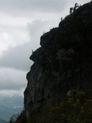
High-elevation spruce-fir forests cover the rugged, rocky summit and higher slopes. Striking natural features on the mountain include steep, rocky knobs, and at least two competing "profile" views that ultimately gave the mountain its name.
The Blue Ridge Parkway and US Highway 221 wind along the southeast side of the mountain, making parts of it (including the Attraction area) easily accessible. (This section of the Parkway - including the Linn Cove Viaduct - was the last part of the Parkway to be constructed and opened in 1989).
A road within the attraction property winds its way up the southern part of the ridge, bringing visitors all the way up into the high elevation forest zone. A good network of trails thread the more northerly peaks and descend into the valleys below, making this an exceptional destination for Blue Ridge hiking.
Hiking Trails
Several long and challenging hiking trails are available in the Park, as well as some shorter and easier ones. There are two main "free parking" areas to access the public side of the park outside the Attraction area, for a more backcountry experience. Parking areas inside the attraction require a fee to access, but give you access to the high peaks more quickly and, of course, include access to the rest of what's there.
West Side Public Access
Grandfather's Profile Hike


There is a big new parking area on the West side of the mountain, just north of the junction of NC Hwy 105 and NC Hwy 184 between Linville and Foscoe. The Profile Trail ascends from the Watauga River headwaters here to the top of the ridge near Calloway Peak where it connects to the Grandfather Trail, making a great summit route.
East Side Public Access
Another public parking area can be found along the Blue Ridge Parkway, at the Boone Fork parking area.
The Daniel Boone Scout Trail, with the adjoining Cragway and Nuwati trails, ascend Calloway from the Blue Ridge Parkway. All of these trails are heavy on scenery and spectacular natural features, and shouldn't be missed.
The Tanawha Trail winds along the middle elevations of Grandfather Mountain, paralleling the Blue Ridge Parkway. It's a fantastic trail, and you can use parts of it to access trails in Grandfather Mountain State Park, but it is covered separately in the Blue Ridge Parkway Section 2 Trailhead area since it's mostly on Parkway property.
The Grandfather Trail runs along the spine of the rocky peak. The south ends starts in the Attraction area and ends at Calloway Peak, passing into the State Park along the way. At an altitude of 5964 ft, Calloway is the highest peak in the park, on the mountain, and in the Blue Ridge range, and rises nearly a mile above the Piedmont region below. The trail passes several other exposed, rocky peaks, alpine meadows, and cool forests along the way - sometimes requiring the use of ladders to negotiate the rugged, rocky ridgeline!
⚠ Caution: Anyone planning to access the Attraction area from one of the public access parking areas should think twice, sleep on it, and think again. It can be done as a very long and strenuous day hike (12+ mi with over 3000 ft climb), but only the most seasoned hikers in tip-top shape should even attempt it. There is no transportation if you find yourself at the Swinging Bridge area without enough time or energy to make it back along the very strenuous trails through the backcountry to the parking areas. Visitors must be out of the Attraction area by closing time, and must have a camping permit to stay at one of the sites within the state park. The only feasible way to hike the most popular parts of the Grandfather trail for most hikers is to pay the fee and park within the Attraction area's hiker parking area. It's worth it.
This is just an overview of the trails in the park. For all the information on each individual trail, visit the Trails page.
Developed Attraction
The Morton family still operates the Grandfather Mountain attraction, with the museum, picnic areas, wildlife habitats, swinging bridge, and concessions. This area occupies roughly the southwest 1/4 of the mountain itself. There is a fee to enter the attraction, but it's well worth paying.
A few trails are only accessible from inside the attraction, and many of the best backcountry trails in the park can also be reached from parking areas there. So even if you're a hard-core hiker, don't miss it and consider starting your hike in the attraction area to fully explore Grandfather Mountain and support an old and distinct local business. For more information, visit www.grandfather.com.

History
Grandfather Mountain itself has long been open to the public as a private park. The "mile-high swinging bridge", which is reached by an easy path after a scenic drive up the mountain's southwest side, is an iconic fixture and a walk across it is exhilarating to say the least. The mountain's rocky, rugged ridgeline makes a picture perfect for postcards. But there's more to Grandfather Mountain - which is also an International Biosphere Reserve and habitat to 70+ rare and endangered species - than can be appreciated solely as a tourist attraction.
Company founder Hugh Morton, a renowned photographer and conservationist, recognized this. He (and his heirs) had a vision to guarantee the mountain's continued protection, and after he passed away in 2006, the North Carolina State Park system reached agreement with the Morton family to purchase "the backcountry" areas of the mountain owned by the Morton family. The purchase took place in 2008, and in early 2009, the N.C. General Assembly formally authorized Grandfather Mountain State Park.
The Nature Conservancy holds conservation easements on a further 4,000 surrounding acres, and while not open to the public, this land is protected from the rampant development common on surrounding mountains, and assures that Grandfather's rare and spectacular scenic beauty will remain into the future.
The State Park is still new, so it is still undergoing a master planning process for its future, but there is plenty to enjoy right now - especially if you like hiking!
Interactive Trail Map
Map Information
Download GPS Data
Click on a route, trail, or point on the map and select the GPS Data tab to download its data.
Data Formats
KML (Google Earth)
KML is the main file type used by Google Earth. If you have Google Earth installed, clicking the KML link should open the trail or point directly in Google Earth for viewing. This is the native file format used by Google Earth, but many other map applications can use and understand KML as well, so if you're not sure which one to download, KML is a good bet.
GPX
The GPX format stands for GPS Exchange - a free, open, XML format for exchanging GPS and map data. GPX is compatible with Google Earth, many other mapping programs, and most GPS devices (such as Garmin). Load the file directly into your GPS to help find your way on your next trip!
GeoJSON
GeoJSON is a newer, lightweight data exchange format which can be used to quickly share map data and may have a smaller size than KML or GPX. Many professional mapping and GIS applications support the GeoJSON format.
About the Map
Copyright
Base Layers
Base layers provided by OpenStreetMap, the US Geological Survey, the US Forest Service, and NC OneMap. Base layer images are subject to the respective copyright policies of their owners. Base layers may not be available at all times due to system maintenance or outages.
WNCOutdoors Base Layer
The WNCOutdoors Base layer is provided by WNCOutdoors.info. It is licensed by Creative Commons Attribution 3.0.
Trail and Marker Overlays
Trail layers and downloadable data are all original works created by WNCOutdoors with guidance from a variety of sources, including ensembles of our own GPS tracks, user contributed GPS tracks, official maps and GIS data from government agencies, and field observations. WNCOutdoors data is made freely available under the Open Database License - you are free to copy and use it for any purpose under the terms of that license (summary).
Tips
- Hover over a trail to see it highlighted. Helps to see start and end points for an individual trail.
- Scroll and zoom the map before printing, and that view will persist into the printed image.
- Click a trail for more details and to download it individually.
Places to Stay
Camping
There are 13 backcountry campsites available along the park's trail system, including the Hi-Balsam Shelter. Camping is permitted only at signed, designated sites. There is currently no fee for camping and no reservations are available, but a fee based reservation system may be implemented in the future. For now, you will need to self-register for a campsite at the trailhead, and they're available on a first-come basis. Campers must park at either the Profile or Blue Ridge Parkway parking areas; no vehicles may be left inside the Attraction area overnight. Camping is not allowed on Blue Ridge Parkway property (the Tanawha trail).
Fires are permitted at lower elevation sites, but use only downed, dead wood for fires. Using a camp stove is recommended instead, and fires may be banned during dry weather. Water is usually available from streams and springs near campsites, but some of them are only intermittent.
Lodging
Lodging is available in the nearby towns of Linville, Banner Elk, Boone, Blowing Rock, and the many resort towns and communities throughout the High Country region near Grandfather Mountain. We suggest www.visithighcountry.com for a searchable, extensive list of places to stay in the area.
Directions
Developed Attraction
From the intersection of US Hwy. 221 and NC Hwy. 105 in Linville, take US 221 East for just over 2 miles to the main park entrance road on the left (following the huge signs and billboards). The park road leads another 2 miles to the top of the mountain, with parking along the way in several places. There is a fee to enter the attraction, which is paid at the gate off US 221.
If you're coming from Boone, starting at the NC 105/US 321 intersection, it is just under 17 fairly straight miles on NC 105 South to Linville (then turn left on US 221). You can also just take US 221 the whole way from Boone, but it is longer (23 miles) and much curvier.
Yet another alternative from Boone would be to take the Blue Ridge Parkway to the US 221 intersection at milepost 305. This is much more scenic than the other routes and less curvy than US 221, but the Parkway can be closed in the winter or bad weather. This route passes the Daniel Boone Scout Trail access (see below), travels around the slopes of Grandfather Mountain itself, and passes over the famous Linn Cove Viaduct. (See the Blue Ridge Parkway Section 2 Trailhead for more details).
Profile Trail Parking Area
From the intersection of US Hwy. 221 and NC Hwy. 105 in Linville, it's just over 4 1/2 miles to the access road to the parking area on the right. If you're coming from Boone, starting at the NC 105/US 321 intersection, it is just over 12 miles on NC 105 South to the access road, on the left.
Boone Fork Parking Area
The park's northeast section is accessible from trails off the Blue Ridge Parkway, at the Boone Fork parking area, milepost 300 on the Blue Ridge Parkway.
The Boone Fork parking area is about 14 miles south of Boone via US 221/Blue Ridge Parkway, or about 6 miles North of US 221 and the Parkway near Linville.
Asutsi Trailhead
Of course, the Parkway closes sometimes, so there is additional parking nearby on US Hwy. 221. The 0.4 mile Asutsi Trail connects up to the Boone Fork parking area from 221, making this section of the park accessible even when snow closes the Parkway (with a bit of additional hiking). This parking area is just under 11 miles north on US 221 from Linville, or just under 15 miles south on 221 (via Blowing Rock) from the NC Hwy. 105 intersection in Boone.